 SECONDNEXUS
 percolately
 georgetakei
 comicsands
 George's Reads


The world burns or cuts down about 15 billion trees a year through mining, logging, and urban development. However, no nations, organizations, or individuals “have been able to plant enough trees to make up for that loss,” according to National Geographic, which results in not nearly enough trees being seeded to combat deforestation.
With big implications for climate change, an increase in mass deforestation threatens the survival of millions of animal and plant species. But as ecological initiatives push to regrow forests and farms like, technology startups may finally have an answer: drones.
NASA veteran Dr. Lauren Fletcher is one of many new tech entrepreneurs using modern machinery, soil-testing, computers and ground-based sensors to make crop monitoring and tending more efficient.Fletcher created BioCarbon Engineering (BCE) to fight deforestation on a mass scale, describing BCE as an ecosystem restoration company that primarily employs an unmanned aerial vehicle (UAV) nicknamed “Robin.”
The 30 lb. Robin drone can fly over the most rugged landscapes on earth, while also planting trees at the rate of 120 per minute. Robin drones scan the terrain and develop a 3D map of the area. Then using data from a developed “smart map,” the team uses an algorithm to carry out the planting strategy. With precise targeting, Robins gently fire seed pods into the earth at a dizzying rate of two per second.
Even after Fletcher put together a team of 12 experts with backgrounds in engineering, community development, ecology, biology, and remote sensing to form BCE, he still had to find the right species of tree: “This is about restoration of local ecosystems, full stop. If you don’t get the biology side right, then you’re not a solution. This isn’t just a convergence of technology. It’s actually a convergence of social will and political power that are all focused on this global problem.”
Speed is the most revolutionary aspect drone seeding and the future of “precision planting” technology. Precision agriculture or smart farming is based on the use of advanced technology in the management of any plants or crops to increase output without compromising quality. Even more promising, drone seeding has the potential to plant 500 billion trees by 2050.
Ecosystem restoration is proving to not only combat climate change, but quickly becoming an emerging and lucrative business opportunity. The need to maintain the balance between cost and quality has made drones particularly attractive for smart farming and reforestation. Drones are affordable and don’t require much training to pilot, but pilots do need certification.
Federal rules around drones were loosened late last year, and special permits were issued to a handful of agriculture operators. As that number grows, the impact on the US farm sector will be huge: The American Farm Bureau Federation estimates farmers’ return-on-investment alone may be $12 per acre for corn and $2 to $3 per acre for soybeans and wheat—which is a lot. And the United Nations projects, assuming a global population of 9.1 billion people in 2050, food production will need to rise steadily by about 70 percent. Improving crop yields will be increasingly key to feeding the starving world, in which drones could play a vital role.
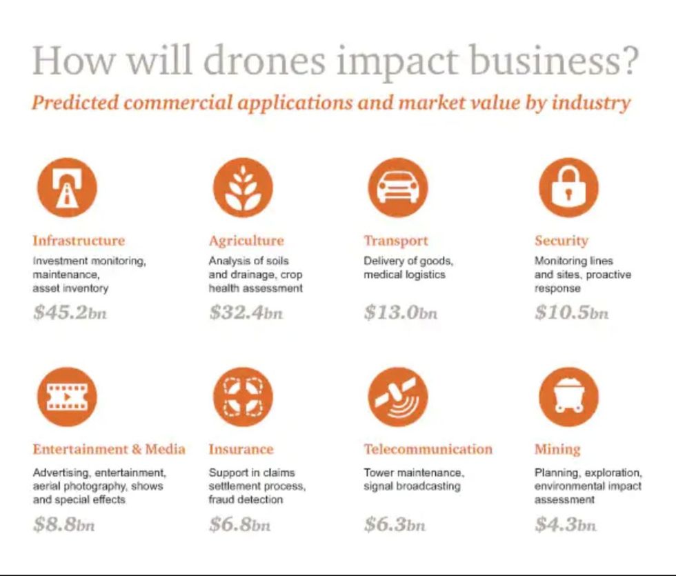
The value of drone-powered solutions in agriculture is estimated at $34 billion, according to a recent PwC analysis; drones can improve food production, increase crop yields, and help a farm’s overall productivity rate. More ecologically-minded tech startups like DroneSeed in Seattle, Washington, are already developing plans to plant seeds; they currently use drones to spread fertilizer and spray herbicide with a multispectral camera that allows farmers to take field shots and identify the state of vegetation. Drone-seeding data identifies problem areas in agricultural fields and consequently monitors the level of germination. Afterward, drone-driven soil analysis provides data for proper irrigation and nitrogen-level management.
Vast fields and low efficiency in crop monitoring have always been farming’s largest obstacle. Monitoring challenges are exacerbated by increasingly unpredictable weather conditions, which drive risk and raise field maintenance costs.
Previously, satellite imagery offered the most advanced form of monitoring. But images had to be ordered in advance, could only be taken once a day, and image quality typically suffered. Now drones with hyperspectral, multispectral, or thermal sensors can identify which parts of a field are dry or need improvements.
In recent years, hundreds of companies have entered the forest and farm restoration industry, but now drones can deliver on a definitive promise to restore agricultural lands.